|
|

LOFTS FARM PROJECT - INTERIM 1979-80This report describes the preliminary results of work carried out by Maldon Archaeological Group between July 1979 and December 1980 in the vicinity of Lofts Farm. Great Totham (TL 86670906) which will be quarried for gravel within the next few years. Previous work on the site and a historical background are described in a similar account printed by the Group in July 1979. Since this time we have recorded visits to the area on 95 days. expended at least 160 man/days of excavation and observation, and taken over 500 colour transparencies as record photographs. ACKNOWLEDGEMENTSThe Group wishes to thank Contractors Aggregates for their co-operation and permission to work on the land and also their donation towards the costs of the Project. We are also indebted to Mr. Rees of Little Braxted Hall for allowing us to keep the excavation trench open throughout the year and available at weekends. The author would also like to thank Mr. and Mrs. Hughes of Lofts Farm for allowing easy access for tools and equipment to the excavation. A grant to pay for topsoil stripping was awarded by Maldon District Council, who also assisted by loaning us surveying equipment. Through the period Essex County Council - Archaeological Section have given invaluable advice and practical help, particularly the assistance of six full-time archaeologists made possible by a County Council grant. EXCAVATION
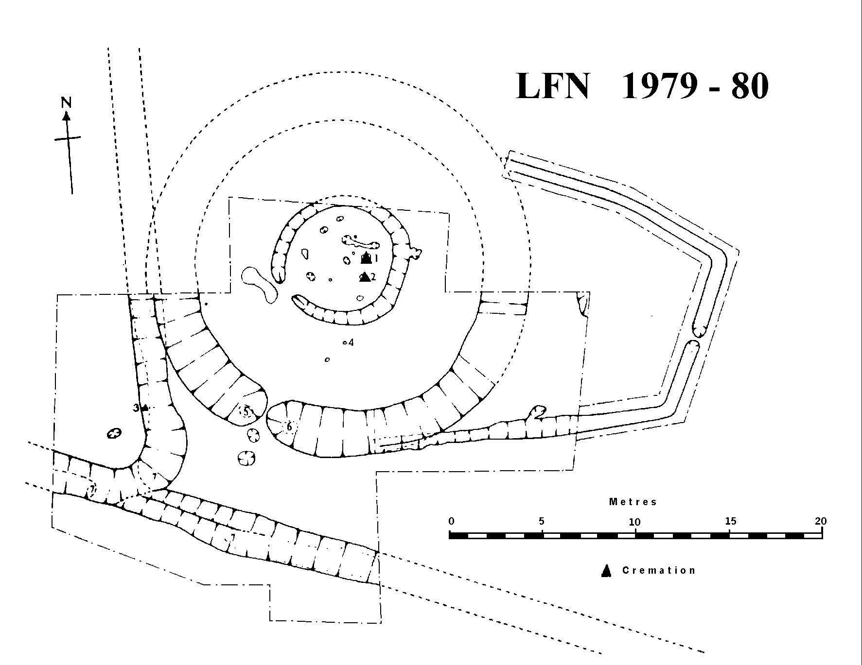
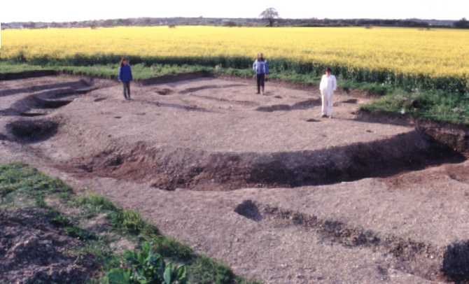
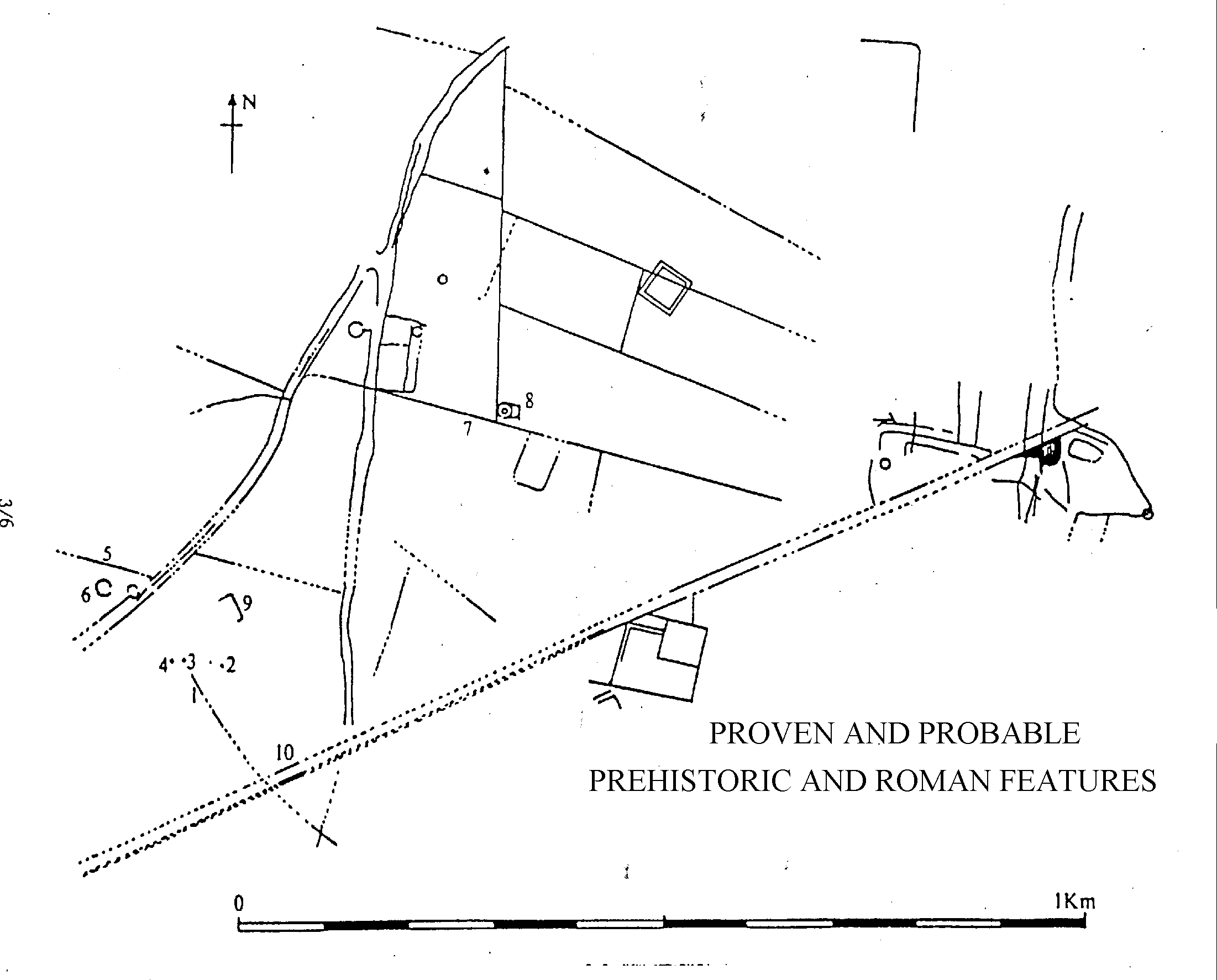
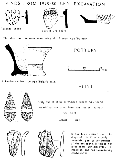
A stratigraphically important element in the crop mark complex in field 'N' was kindly left uncultivated by Mr. Rees to allow M.A.G. to carry out a detailed excavation. In September 1979 approximately 400 sq. metres of topsoil were removed by machine to uncover parts of three or four crop mark features. Eleven months later this trench was extended to include another crop mark and also more of a newly discovered ring ditch. The main features were concentric ring ditches with south-east facing "entrances", three cremation burials, an enclosure with a narrow east facing "entrance" and two field ditches. The west field ditch and the east enclosure clearly post-dated the outer ring ditch. Cremation 1 was the deepest and, unlike the other two, was not associated with an urn. However. some of the charcoal with the burnt bone fragments suggest a wooden vessel may have been involved with the burial. The remains of Cremation 2 were only 30 cm. below the modern surface and are a remarkable survival. It is probable that other cremations have been destroyed by the erosive effect of centuries of ploughing. This Interpretation was strengthened by the presence of several urn sherds around the site.
SITE SEQUENCEInitial study of the finds and results indicate the following Sequence: PHASE 1 : A barrow, comprising the ring ditches around Cremation 1, was constructed in the early or middle Bronze Age. Two small post holes, one containing a Beaker sherd were found within the centre circle. The possibility of a central structure is hinted at by the size and form of the inner ditch. Although other burials were placed nearby, the deep outer ditch was allowed to silt up and was eventually lost. PHASE 2 : A field system was laid out in the Iron Age. It would appear that remains of the barrow were still visible since field boundaries were positioned to include the monument in the corner of a field. The east enclosure ditch may have been dug at this time to utilize remnants of the barrow for some agricultural purpose, although it could equally represent the last phase of the site's ritual significance. PHASE 3 : Three separate cuts of the field ditches were discernable, the last of which was Romano/British and involved the creation of new field entrances by terminating the recuts in butt ends and spreading gravel over the old silted ditches. It seems unlikely that this position for an entrance would have been chosen if any trace of the barrow remained. PHASE 4 : This field system eventually fell out of use and no trace of it can be recognised in the field layout that we have today. OBSERVATION OF OVERBURDEN STRIPPING
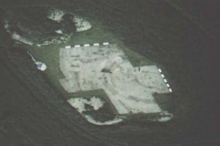
The quarry pit has now encompassed all the fields south of Lofts Farm, i.e. A, B, D, F, G and H on the plan, although most of F and G have been reinstated as farmland. Inevitably, archaeological evidence would be destroyed in our absence, but it was hoped that numerous lunchtime visits would be sufficient to record an outline of the early fields which will eventually relate to dated features elsewhere on the site. Features recorded included small lengths of field ditches, one straight 28 metre side and two round corners of an 'enclosure' (9 on above plan). the bottom of the MEDIEVAL 'moat' and a large POST MEDIEVAL pit containing burnt red earth. The precision with which the 'enclosure' was dug and the nature of the fill tempts one to postulate a ROMAN origin, despite the absence of any finds. A small shallow pit was the only prehistoric feature that could be dated by its contents which were NEOLITHIC sherds and struck flint flakes (2 on plan). The most interesting of the ditches were small parallel lengths of ditch in field 'E' (10 on plan) which clearly continue the parallel ditches visible in the crop mark photographs entering the threatened fields from the north-west. Having identified approximately a 1 km. in length, it seems probable that it formed part of a trackway or road to the ancient settlement or port of Heybridge, less than 2 km. to the south-west.
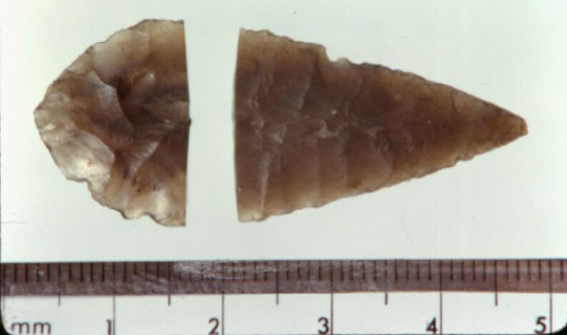
Flint examples drawn by H.M. of ESSEX COUNTY COUNCIL SUMMARYThe latest discoveries may not have the same impact as the earlier Neolithic pottery or Iron Age hut circle, but the results are certainly of equal importance in understanding this historic landscape. The chronological sequence of the crop marks suggested previously remains unchanged and, in some respects, is further substantiated by recent evidence. The sequence in broad outline is:-
Recent changes in the method of topsoil stripping in the gravel pit has made it unlikely that we shall see such clear traces of early features in future. This emphasises the importance of prior excavation in selected areas before they are destroyed by gravel extraction. However, with continued interest and active support we can still look forward to achieving all the principal objectives. The finds will be deposited with Colchester & Essex Museum as the full reports are written, but can be made available now for inspection by prior arrangement with Paul Brown, 152 Fambridge Road, Maldon, Tel. Maldon (0261) 57315. This report would not be complete without a special mention of all the volunteers who have helped in the work and especially Brian Chinnery, Elaine Brown, Malcolm and Frances Billinge, Dave Gustard, David and Richard Jennings, Geoff Clark, Nobby Clark, Andrew Jones, Gillea Crossley, Anna Cronin and Tony Froom. The following businesses have assisted the Group by allowing us special discounts: D N W Orriss - machine stripping, Reeve & Son Ltd - wheelbarrows, H Springett - photographic materials, Tesco Ltd - packaging (paper bags). AppendixBone from Cremation 1The cremated bone from the barrow's 'primary' burial has been kindly examined by Dr. Judson Chesterman of Sheffield University. He was unable to identify any human bone in the sample and believed them to have been mostly of pig. Radio Carbon Dating from Cremation 1 SampleThanks to a grant from the Lloyds Bank Equipment Fund we have been able to obtain a carbon date from the small quantity of charcoal found with the bone. Harwell Low Level Measurements Laboratory have provided the following results:
|
|
|